Bush
Employment - Outward Bound

Date: 2014 -
Location: Queen Charlotte Sound, Marlborough Sounds
Level: Varied: Easy to medium. Track through to off track.
Days: 90
Hours: 700
No. of People: 1:14
Weather Conditions: Variable: Fine, hot, windy, cold, snow, rain.
Extra Comments: A variety of mostly two and three day tramps with students.
Location: Queen Charlotte Sound, Marlborough Sounds
Level: Varied: Easy to medium. Track through to off track.
Days: 90
Hours: 700
No. of People: 1:14
Weather Conditions: Variable: Fine, hot, windy, cold, snow, rain.
Extra Comments: A variety of mostly two and three day tramps with students.
Personal - Lake Henderson, Cobb Valley
Date: 31st May -2nd June, 2014
Location: Kahurangi National Park, New Zealand
Level: Medium
Days: 3
Hours: 24
No. of People: 2
Weather Conditions: Fine, very cold
Extra Comments: This is the coldest I have EVER been on any tramp. Probably rates in my top 3 coldest nights of all time. We woke up with frost inside the tent and water bottles etc frozen - may as well have slept in a snow cave. Also rates in my top three most beautiful tramps of all time so yes, I would go back.
Personal - Cowin Spur
Date: 28 -30 March, 2014
Location: Kahurangi National Park, New Zealand
Level: Medium
Days: 3
Hours: Lots!
No. of People: 2
Weather Conditions: Cloudy
Extra Comments: Probably one of the most painful tramps i've done - 1300m pretty much straight up. Blisters on the way up, in the process of losing a big toe nail from the way down...GORGEOUS on the tops though. Had planned to hit up Loveridge Peak and the Twins but on Day 2 realised we were moving so slowly we probably weren't going to make it out until middle of next week as on closer inspection the ridgeline called for time and mountain equipment, neither of which we had...so we turned back and went 1300m right back down!
Personal - Gordon's Pyramid
Date: 22.2.14
Location: Kahurangi National Park, New Zealand
Level: Easy/med
Days: 1
Hours: 10
No. of People: 3
Weather Conditions: The most variable i have ever experienced in my LIFE! Forecast: 'Showers clearing after lunch' Actual weather: Wind gusts at 45km/hr on the tops, freezing cold and crazy rain followed by utter calm and sunshine.
Extra Comments: A day tramp to 'get amongst it' again and practice Nav. It has been a while since i've been out on the tops and to be honest I had forgotten the magic feeling of being a little person in an untouched expanse of wilderness. Love it. Hooked. Yes.
Personal - Grampians
Dates: 9.2.14
Location: Grampians and surrounds, Nelson New Zealand
Level: Easy/med - off track micro nav
Days:
Hours:
No. of People: 1
Weather Conditions: Variable - fine to rain
Extra Comments: A great place to practice micro nav. I'm just going to keep going back until I'm amazing at it. And then i'll keep going back.
Personal - Harwards Hole
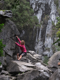
Bouldering in front of the sink hole
Date: 20.5.13
Location: Harwards Hole, Cannan Down, New Zealand
Level: Easy
Days: 1
Hours: 3
No. of People: 2
Weather Conditions: Fine & cold.
Extra Comments: I will be the first to admit that Harwards Hole hardly counts as a tramp or 'bush' event. It is the most spectacular sink hole in the southern hemisphere and deserves being recorded more for its reputation than anything else. The journey is an easy 45 minute walk and the enormity of the sink hole itself is worth a ten day tramp.
Employment - Strathcona Park Lodge

Date: 1st - 5th October, 2012
Location: Philips Ridge, Strathcona Provincial Park, Vancouver Island BC, Canada
Level: Easy - moderate, mostly on track, some off track
Days: 5
Hours: 50
No. of People: 1:5 Instructor - Student ratio. 10 students.
Weather Conditions: Fine & cold.
Incidents: While climbing a slope one student was hit on the head by a falling rock suffering a scalp laceration and mild concussion. Decision was made to evacuate by walking out. Was given the all clear by hospital later that evening.
Extra Comments: A three night, four day hike to Arnica Lake campsite with day trips to Phillips Ridge and Mt Phillips respectively. Taught navigation and leadership skills.
Tofino Mission
Date: 1st June, 2012
Location: Tofino, Vancouver Island BC, Canada
Level: Moderate, off track
Days: 1
Hours: 6
No. of People: 2
Weather Conditions: Rainy
Incidents: Nearly spent the night out
Key Learnings: Don't trust the locals!
Extra Comments: This entry was never intended to be significant enough to be an entry. What started as a stroll on the beach turned into an almost-staying-out-the-night saga. We were told by a local it was possible to walk the entire way from Longbeach to Tofino via the beach.
We saw a headland with a few rocks and started rock hopping to get onto the next beach, the next headland same story. Two and a half hours later we had become engrossed in the rock hopping with some grade 13 rock climbs in tennis shoes that we only just realised the rest of the coastline as far as we could see was rocks. We decided to bush bash to the road but after doing a complete circle in less than 20 minutes we decided to head back to the rocks. Adding to this decision was the fresh bear tracks - so fresh in fact I think Mr. Bear had just scampered off to get a bottle of wine and some cutlery for his dinner guests - us.
At about 8pm we started to talk about the failing light, high tide and possibility of not making it out that night. Half of me started to look for a good rock to huddle under. 6 hours later we finally emerged on the road and at 10pm got back to the hostel after being picked up by a Tofino local.
Day Hike

Date: 12.4.12
Location: 9 Mile, West Coast New Zealand
Level: Easy, off track
Days: 1
Hours: 4
No. of People: 2
Weather Conditions: Rain
Extra Comments: Took Chester hunting for the day. Didn't catch anything but the flu! :(
Location: 9 Mile, West Coast New Zealand
Level: Easy, off track
Days: 1
Hours: 4
No. of People: 2
Weather Conditions: Rain
Extra Comments: Took Chester hunting for the day. Didn't catch anything but the flu! :(
Heaphy Track

Typical West Coast beauty
Date: 23rd - 25th Jan, 2012
Location: Heaphy Track, West Coast New Zealandd
Level: Easy, flagged route
Days: 3
Hours: 36
No. of People: 5
Weather Conditions: Fine
Incidents: 4 out of 5 people with relatively dehibilitating foot injuries!
Extra Comments:
Ari strained a muscle in his foot, Regina and Jason had blisters the size of houses despite having boots that are well worn in and I had bone spurs that played up somethiTng shocking, I think my feet have changed shape since the adventure race, my climbing shoes don't seem to fit anymore either. End result was Ari walked barefoot, Jason in sandals, Regina in my boots and I finished the track in jandals.
Amazing scenery, the track is quite deceptive because it is so flat it appears easy but it is quite tough on the body as it is the same movement for 84k's with no ascending/descending to break it up. 32k's the first day, 35 the second and 17 the last.
When I hit the coast I felt like I had come home, the West Coast is the first place I got to call home in New Zealand and it will always have a place in my heart. Highlight was the helicopter ride home, a friend of mine knows someone who got us a deal on the flight. Amazing!
Abel Tasman National Park

Date: 13th December, 2011
Location: Abel Tasman National Park, New Zealand
Level: Easy, track
Days: 1
Hours: 5
No. of People: 2
Weather Conditions: Rain
Extra Comments: Walked from Anchorage to Marahau and explored every side track, trapping track and detour we could find. Bush bashed out to the ‘lighthouse’ and finally got home in time for dinner.
Bushcraft Skills

Date: 9.10.11
Location: Cobden Beach
Hours: 1
No. of People: 5
Weather Conditions: Windy
Extra Comments: Had a bushcraft fire lighting afternoon with Chris at the beach (still need to wear thermals, a fleece and a beanie to go to the beach on a sunny day in October...love Greymouth). He taught me a lot of tricks and skills for lighting a fire in windy/wet/dry conditions. Did a neat experiment with wind and flax - amazing what can result when you know how to really feed a fire.
Nelson Lakes - Ella Range

Date: 13th - 16th September, 2011
Location: Nelson Lakes - Ella Range, New Zealand
Level: Moderate, flagged route, some off track
Days: 4
Hours: 32
No. of People: 8
Weather Conditions: Snow, rain, cold
Incidents: Got turned around halfway as snow too deep to continue
Extra Comments:
A fairly epic tramp (aren't they all?!). Our original plan to mission onto the 1000 Acre Plateau got canned literally the morning we were leaving as the weather turned quite foul. The new plan then became about finding a location where the weather wasn't going to be quite so ferral. New plan: start at Matakitaki, head up over the Ella Range and up to Lake Angelis Hut and come out at Lake Rotoiti.
We had snow starting at 500m in places and once we got onto the Ella range the snow progressed to thigh deep...and with my special talent for finding difficult holes to get out of - I managed to bury myself chest deep. The bush was amazingly beautiful with such a large amount of snow - however it did make it amazing tough to navigate through!
On the 2nd night we had a radio call from the second half of the polytech team doing the same tramp in reverse - they had to turn around part way up Angelis as the snow was too deep. That meant we too had to turn around and head back the way we had come. We chose a slightly different route to make it more interesting - it definitely got interesting with 700m of elevation thrown in over about 2k's. Add that to snow, ice and slush puppy wetness and the third day was definitely a mission.
Beautiful trip, was a great experience to tramp and camp in snow. Definitely prefer summer tramps though (still an Aussie at heart!).
Milford Sound Track

Date: 4th September, 2011
Location: Milford Sound, New Zealand
Level: Easy
Days: 1
Hours: 5
No. of People: 3
Weather Conditions: Fine, cold.
Extra Comments:
Whilst at work experience we were fortunate enough to have a chance day without clients. Paul gave us the option of taking the boats up river to the start of the Milford Track to explore for the day. He didn’t have to ask twice – we were on it like a shot. Stepping foot on the track was quite a moment for me, exploring the Milford Track was a throwaway goal I had catalogued into the ‘one day when it happens’ bin when I was twenty years old. Well it suddenly happened, quite without me even making any concerted effort to get there and before I can blink I’m walking the Milford Track, with not a single other soul on it but Tui, Chris and myself. How incredibly lucky were we! The walk itself was easy – built for the masses it was a graded track & easily followed. The views were second to none, especially a magic waterfall we came across for lunch. What seemed particularly neat about this trip was that it was a multidiscipline trip....paddling to the beginning of the track, walking and then paddling back. Neither the paddle or the walk was particularly difficult but I guess it is akin to catching a boat and then a bus to get to work – except our office was the Sounds. I unabashedly state, I love my life!
Tech - Survival

My 'coffin' for the night - a tight fit!
Date: 14th - 16th June, 2011
Location: Arahura Valley
Days: 3
Hours: 36
No. of People: 14
Weather Conditions: Rain, cold
Key Learnings: It is worth spending every minute possible on a shelter, because it is all I will have.
Extra Comments: This was a truly epic experience.
Day 1: 'Survived' as a group, making a solid shelter with ferns and tussock grass. A fourteen person spoon ensured a chilly as opposed to frozen sleep.
Day 2: Day 2: This is where the epic-ness begins... made my solo shelter in the rain under a fallen tree, as small as possible to reduce air flow and compress the space I was in. First fatal mistake was not measuring my sleeping spot. Second fatal mistake was attempting to sleep in my pack. Turns out I had a claustrophobic reaction to my cribb (never have before...but when i'm trying to sleep in something akin to a slightly too small coffin...I can understand my own reaction!).
Created a mini weather system in my pack resulting in soaking wet clothes in 2 degree weather. Did circuit aerobics from approximately 10pm until 4am to keep myself warm. Fell asleep sitting on a log. Woke up when i fell off the log and hit the ground. Got cold. Hallucinated - saw Bambi, had a rave party in my head, heard Ethel tell Merv to turn the tap off. Did more aerobics. Stopped. Got cold. Wished Bambi would come back. Kept doing aerobics until 9am.
Epic.
Waimakiriri Valley

Navigation up the valley
Date: 4th - 7th June, 2011
Location: Waimakiriri Valley, New Zealand
Level: Medium, poled route
Days: 4
Hours: 30
No. of People: 4
Weather Conditions: Fine to rain
Key Learnings: Don't overpack!
Extra Comments: Got inspired after Ice Climbing to have an epic mission through the Waimakiriri Valley and up to Barkers Hut. Started off in the pouring rain, packed too many clothes and had to suffer for it the next three days. I packed when I was tired and as a result must have thought I was going to the Ritz or something. I have chalked that lesson up on the board - don't overpack!!!
The trip to Barkers Hut was incredible, a beautiful beautiful valley (wet feet for four days though!) with epic views and a good climb up to the glacier. Luke had a short stint ice climbing before we had to turn back to make it to the next hut before dark. We discovered the tarn wasn't quite frozen enough to skate on when it cracked and broke into shelves of ice...classic.
Mt Brown

Date: 29.5.11
Location: Mt Brown, New Zealand
Level: Easy/medium, half on track, half bush bash
Days: 1
Hours: 6
No. of People: 3
Weather Conditions: Fine
Extra Comments: Went on a nav trip to Mt Brown and immersed ourselves in a muddy supplejack mission. After a few hours we turned back as we wouldn’t be able to summit and return before dark. Am planning a trip for Queens Birthday long weekend so will get more nav practice in there.
Mt Arthur

First snow of the season
Date: 21.5.11
Location: Kahurangi National Park, New Zealand
Level: Easy, on track
Days: 1
Hours: 5
No. of People: 6
Weather Conditions: Cold
Extra Comments: Got to see my first snow for the season - as an Aussie snow is something i haven't seen a lot of - love it! Kellie and I decided not to summit, the others went ahead and we spent an hour and a half practising our nav - identifying features and matching the map to the terrain. It was truly time well spent and I'm really glad I spent the time to do it.
Greymouth
Date: 14.5.11
Location: Greymouth
Level: Easy, 1/2 on track - 1/2 off track
Days: 1
Hours: 2
No. of People: 4
Weather Conditions: Rain
Extra Comments:
Today started out as a kayak day but when we got to the river they were way too swollen by flood and full of debris to paddle safely. We then went to the surf however it was choppy and not great conditions so we changed our mission to a tramp/nav day out the back of Grey. Kieran helped me with identifying features and I’m starting to get a better picture of what I’m looking at versus what it looks like on the map. Am looking forward to doing more tramps later in the term.
Totaranui to Separation Point
Date: 8.5.11
Location: Tasman, New Zealand
Level: Easy, on track
Days: 1
Hours: 5
No. of People: 2
Weather Conditions: Fine to rain
Key Learnings: Don't make assumptions.
Extra Comments:
A friend and I agreed to do a popular tourist tramp out to Separation Point (Abel Tasman Area) to see the seals. I made a whole lot of assumptions (it would be an easy walk... as it was a tourist area it would be well signed so we wouldn't need maps...it would be a short walk so we wouldn't need food...it looked fine so we didn't need good wet weather gear...we weren't going to be gone long so a rough 'we'll be back about this time' covered my intentions... - I cringe as i read it now!). What I thought would be a straightforward tramp turned out to be a five hour debacle with poor signage which meant we walked an extra hour and a half loop that had nothing to do with our final destination, we got wet because it rained, had the potential to get hungry because we were out for so long...had a third person waiting to pick us up for an extra few hours...and to cap it off wound up wading through a waist deep tidal pond to get back because I hadn't done my research about the track! My friend was brlliant and took it on the chin. We laughed about it lots afterwards however the mistake of underestimating a 'tourist walk' will forever stay with me as a big reminder of 'I never truly know what the conditions will be until I'm out there...so be prepared for anything!'
Lake Christobel to Lewis Pass

Date: 22nd - 25th March, 2011
Location: Lewis Pass, New Zealand
Level: Medium, partly on track, mostly off track
Days: 4
Hours: 32
No. of People: 8
Weather Conditions: Fine and windy
Key Learnings: If we are to experiment with fish...carry it on the outside of our packs.
Extra Comments: How do I adequately describe four days of tramping through some of the most breathtaking country I have ever seen? Starting out at Lake Christobel I scored three wasp stings in the first hour of the tramp – not ideal. For the first night we were lucky enough to have fish for dinner, we carried it in frozen and it lasted the tramp in for dinner just fine. The part that wasn’t fine was both Kieran’s pack and mine smelled like fish for the next four days – he carried it in and I carried the rubbish.
When tramping, it seems to be a bit of a cliché term to ‘go where no-one has ever been before’. That can often be quite hard as tramping is very popular in NZ and everybody has been somewhere right? I can fairly confidently say we took a route up to ‘Tangerine Bowl’ (our name – not officially correct!) via a route just about no-one would be likely to do. As a group we decided it would be...what shall I say – ‘an experience’ to use the creek as a handrail and take the shorter but steeper route to the tops. It definitely was shorter, steeper and also full of close growing trees, closely fallen trees, shrubs, intertwined shrubs and other difficult-to-get-through material that made every step difficult. Perseverance won out however and we triumphantly ate lunch just clear of the tree line.
We found a suitable campsite and proceeded to set up camp in moderate winds. Zack then decided to make us work for our muesli bars and designed a scavenger hunt with micro nav – seven checkpoints involving pacing, boxing, accurate bearings/back bearings and a bit of scouting. The moderate winds then opened out into full blown intense winds so we cooked dinner whilst lying in the foetal position (on reflection, I’m not sure why we didn’t retreat to our tents for a ten minute reprieve!), which led into listening to the mountain radio weather broadcast in a penguin huddle. It was somewhere between our foetal position dinner and the penguin huddle that Robbie left his sleeping mat to get a cup of tea, he had scarcely stood up when it was swiftly claimed by the wind and hurled into the air and down the valley. He made a valiant effort and ran nearly a kilometre, but the tangerine sleeping mat had done its dash and disappeared – hence the ‘tangerine bowl’ was named. The final morning we woke at 4am for a ‘night mish’ or night nav – it was a completely rewarding experience working our nav skills in the dark and learning to use the features around us in a new way. The sunrise that morning was an amazing glow of colour, I felt very privileged at that moment to be alive at on the Lewis Pass tops, where else in the world can you get a loo with a view like that!
I am more than happy to say the mountains truly came alive for me on the van ride home. I couldn’t help but see contour lines every time I looked at the mountains in the distance and even when I closed my eyes the orange scrawls continued to wind their way behind my closed lids. For the first time I am starting to feel like nav is a skill I have under my belt. To sum it up, I am sporting a pair of sore knees, my feet feel as though they have been punished for a crime they didn’t commit but I am so grateful for the amazing experience I had of Lewis Pass, it is stunning in its vast remoteness and put me in a very contemplative state of mind.
Cobden Hill

Date: 12.3.11
Location: Cobden Hill
Level: Easy, off track
Days: 1
Hours: 4
No. of People: 2
Weather Conditions: Fine
Extra Comments: I’m not entirely sure this counts as ‘bush’ as we didn’t have a map or compass and it wasn’t even a full day - however if popping out of Cobden Hill wearing half the bush and having just navigated through intensely thick supplejack for the past 4 hours counts, then we went bush. Cobden Hill has always looked impressive to me as I drive back ‘home’ to Grey and I’ve wanted to climb it for a while to see the view. Not finding any maps in the shed or on Google, Tui and I decided it was just a hill, it couldn’t be too hard to climb. Right? The first part was simple – the walk to the official look out probably took no more than 15 minutes. Problem for us budding adventurers was a) it wasn’t even close to the top of the hill and b) 15 minutes on a graded track is hardly a decent effort. With the bright eyes of up and coming navigators we found a potential ‘path’ (first thought to be a goat track, later downgraded to a wecker path and then given up on completely as any sort of trail). We climbed over the lookout and headed forward – for about 5 metres and were then faced with a mess of supplejack vines. Not deterred, we alternatively ducked, climbed and bashed our way through to the ‘end’ of the vines, walked another ten metres only to be met with more of the same.
I won’t bore you with the rest of the trip details (supplejack, supplejack, supplejack) however we did find a neat ‘cave’ made from a combination of one very large and very old tree situated next to a few boulders. That is definitely a place I would be happy to have a hermit weekend in and bed down for the night. More supplejack (I think you are getting the picture now) led to the top of Cobden Hill where I was sorely disappointed that there was no clearing, no sunshine and no view. In hindsight, I guess that’s why the lookout is where it is! We fought our way back down the hill and honestly still have no idea if we completely missed a well marked track and subsequent lookout or if only the weckers and outdoor rec’ers climb the ‘full’ version of Cobden Hill.
Greymouth
Date: 10.3.11
Location: Greymouth, New Zealand
Level: Easy, on track
Days: 1
Hours: 7
No. of People: 7
Weather Conditions: Fine and sunny
Extra Comments: Today was a lot of micro nav - finding the small nuances in a countour map and applying it to the surroundings. I had no idea there was so much great bush right at the back of Greymouth. A good day, lots of learning and good times.
Lake Rotoiti

Date: 26th & 27th Feb, 2011
Location: Lake Rotoiti, New Zealand
Level: Easy, on track
Days: 2
Hours: 10
No. of People: 3
Weather Conditions: Fine to rain
Extra Comments: A very impromptu trip, we decided on a whim to hike around the lake.
It turned out to be a much gentler track than what we had anticipated, meaning we arrived at the hut quite early, however just managed not to get rained on in classic Greymouth weather. Our biggest challenge was a slightly below kneeish (depending on how tall you are!) creek crossing. Having never used gaiters before coming to NZ, I have nothing but praise for these nifty little pieces of gear.
We had a magic time at the hut and met some great people...which morphed into a long night playing cards and 'spoons'. It may have been something like a 1am finish (didn't I go hiking to get away from these late nights!?!?!).
The trip out was fairly easy, ending with a swim in the lake for the more courageous souls who have
acclimatised to New Zealand weather! Wildlife I can name - massive eels around the jetty and some very forward (and tourist fed) ducks who promptly took my much anticiapted sandwich out of my hands. That's the last time i ever call ducks 'cute'.
Trip highlight: A date proposition from one of the guys in the hut. Very unexpected but sweet. Shame he lives in the US! Better luck next time :D
Cedar Flat Hot Pools

Life in perspective
Date: 20.2.11
Location: Cedar Flats, New Zealand
Level: Medium, flagged route
Days: 1
Hours: 8
No. of People: 6
Weather Conditions: Light rain
Extra Comments: A hike to celebrate my 26th birthday - just two weeks into the course a few people rallied together to undertake our first 'expedition'. It felt quite exciting organising, travelling to and executing our trip - I felt very grown up which is unusual, because 26 is well into the 'grown up' phase of my life!
It was a great trip - four hours to the pools which included a definite amount of boulder hopping time (I really need to practise this), definite amount of uphill time (more fitness never hurt anyone) and a definite amount of well deserved hot pool time (I don't think more hot pool time hurt anyone either!). Sitting in the hot pools, eating lunch and feeling the rain fall on my skin was a great way to spend my birthday in a new country.
The pools are quite small so any more than six people would have been difficult. The trip back was a lesson in downhilling on slippery tree roots and rocks. Keep looking ahead, place my feet and keep moving them are my three hot tips from the trip. When we got back I know I felt like I had worked hard - and had a great day.
Paparoa's

Date: 14-17 Feb, 2011
Location: Paparoas, New Zealand
Level: Medium, poled route
Days: 4
Hours: 18
No. of People: 10
Weather Conditions: Fine
Extra Comments: Started out with a creek crossing to get to the beginning of the moonlight track. Had some trouble finding the track at times due to the large amounts of rain over the Christmas period so we spent some time making cairns for the other groups to use as a guide. Found a tough ascent towards the end of the day which was all worthwhile for a stunning campsite on the first night. A few of us slept under the stars without tents which was magic, but a little dewy in the morning! I officially need to 'harden up' as my clothing may have resembled two pairs of gloves, a beanie, neck warmer, excessive thermals, fleece type things and huddling under my sleeeping bag like the world was ending.
Tripped around the ridges on day 2, spent time on nav - particularly timing stretches of our hike. Dropped in at the hut for water and continued to enjoy the views with a brilliant sunset on the final night. Slept outside again with no fly and regretted it this time...windy and cold!!!
A lengthy, but manageable descent on the final day, finishing with a swim in the freezing sea (maybe the New Zealand sea will always be cold to an Australian!) to wash off 3 days of sweat and dirt.
